
Pflugerville Previous Residents by Era
The first source depends on the date and on the parcel’s county. Current CAD data can establish the modern parcel, but it is not a continuous occupancy log. Travis deeds appear online generally from the mid-1980s forward, with older books, microfilm, and Portal digitization. Williamson access is likewise name and date based, with county, Baylor, and TSLAC microfilm routes. Directories, census schedules, tax rolls, and plats provide a second layer when a deed identifies an owner but not the people at the address.
| Source | Years it covers | Where held | What it can show |
|---|---|---|---|
| Travis online property index | Generally mid-1980s to present | TCCSearch and County Clerk | Grantor, grantee, instrument date, and legal parcel, not an address index |
| Travis deeds and indexes | Deeds 1840-1919; indexes 1842-1924 digitized | Portal, Clerk, Archives, microfilm | Earlier transfers, liens, easements, and legal descriptions |
| Williamson deed route | County records from 1848; microfilm guide runs from 1835 | County Clerk, Baylor, and TSLAC | Direct and reverse party indexes, books, and page references |
| Austin Criss Cross | 1939-2002 with gaps | TSLAC and Austin History Center | Regional address or telephone clue to a listed occupant |
| Travis rural directories | 1957 and 1958 | UNT Portal to Texas History | Pflugerville names, roads, routes, post offices, and telephone clues |
| Federal census | Released through 1950 | NARA and approved genealogy databases | Household, age, relationship, and changing census geography |
A present-day Pflugerville mailing address does not pick the source on its own. Check whether the parcel lies in Travis or Williamson County first. For a rural-era location, save every old road, route, box, community, and precinct term because it may be the only bridge to the modern parcel.
Pin a Pflugerville Parcel First
Start with the City of Pflugerville address GIS for city or ETJ context, then open the correct county property card. Travis CAD searches owner, property address, account number, and DBA. WCAD uses Name, Address | Account, or Property ID modes. Record the current situs address and mailing address separately, together with the account or Geographic ID, owner name, legal description, subdivision, block, lot, and the date checked. A map point or mailing city is not enough to establish a legal parcel.
WCAD sample cards show why this step matters. A card can carry a Pflugerville mailing address while the situs is in Taylor or Coupland. It can also show a trust, estate, company, or spouse pair as owner. Those fields are valuable search leads, but they do not establish a complete household or uninterrupted residence. The legal description is the durable bridge when the street number disappears from older deed books.
Follow a Pflugerville Deed Chain
For a Travis parcel, TCCSearch Real Estate organizes the index by grantor and grantee. Enter a party as LastName FirstName. For a Williamson parcel, open Williamson Official Records from the county clerk’s Search Records page. Williamson warns that the system is not indexed by legal description. In both counties, the address begins the investigation, but names, dates, and legal parcel terms move it backward.
- From the CAD card, write down the current owner, county, legal description, subdivision or tract, and account reference.
- Search the current owner as grantee to locate the deed into that owner. Check the image, not just the index row.
- Extract the recording date, seller or grantor, buyer or grantee, legal description, prior instrument reference, and any liens or easements shown.
- Search the seller as grantee in earlier years. If the party is an estate, trust, company, spouse pair, or variant spelling, search each relevant form.
- Repeat until the legal description changes or the online index ends, then continue with the clerk, archive, Portal, or microfilm route.
The seller on the purchase deed is the next person to test as a prior owner, not necessarily a prior resident. A probate case, rural directory, census schedule, or tax roll can later support the household part of the trail.
Use Pflugerville Deed Archives
Travis County Archives describes older books and microfilm as the fallback when online records end. Its Portal coverage includes more than 300 books, with deeds from 1840 to 1919 and index material from 1842 to 1924. The Travis County Archives accepts appointment-based research at 5555 Airport Boulevard, Room 507, Austin. Williamson records begin in 1848, and the TSLAC/Baylor guide lists direct and reverse deed-index runs plus original deed books. Write down book, page, reel, image, and date as the work proceeds.
The Williamson County public-scam warning illustrates an important copy distinction for a deed trail.
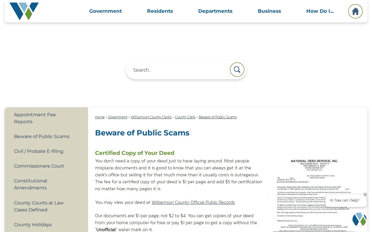
Williamson says unofficial copies from its online system are free, while certified deed copies are listed at one dollar per page plus a five-dollar certification charge. The same warning notes that homestead filings are free through WCAD. Confirm current fees with the office before ordering, and use the official county path rather than a solicitation.
Bridge Old Pflugerville Addresses
Earlier records may describe a road, route, box, post office, survey, abstract, or adjacent owner instead of a modern house number. Do not force a modern address into an older record. Use the subdivision plat to move from block and lot to a tract, or use tax rolls, survey records, county roads, and deed references for a rural property. Travis survey material begins with 1838-39 Bastrop-era records and connects later subdivision descriptions to earlier land vocabulary.
The research did not locate a verified citywide Pflugerville renumbering year or a complete historic annexation address crosswalk. That is a real gap. A current City Limits layer is evidence of today’s boundary, not proof that an address carried the same number or municipality in an earlier year. Preserve the old spelling and all route terms before trying a modern GIS search.
Compare 1957 and 1958 Pflugerville
The 1957 and 1958 Travis County Rural Directories are the strongest verified local address snapshots for previous residents. They cover farms, rural roads, post offices, town entries, and Pflugerville-area names. A directory entry can contain a name, spouse, house number, road, mailing address, telephone, and a work or activity field. For household research, record the name, spouse, address, telephone, ownership mark, page, and the printed form of the surname. A repeated entry is evidence for those two snapshots, not proof of uninterrupted residence.
The digitized 1958 Travis County Rural Directory is the second year to compare.
Its key uses * for home owner, Bx for box, PO for post office, Rt for route, Rd for road, and FR for farm road. Pflugerville is abbreviated PFL, and EDgewood is the telephone exchange. Search the PFL town section and nearby rural-road pages, then compare the same surname in the other year.
Pair Pflugerville Directories and Census
Directories and census schedules answer different questions. The directory may provide a road, telephone, spouse notation, or ownership mark. The census can place a household within its enumerated geography, but that geography may use a county, precinct, township, beat, rural route, or community label instead of today’s city limits. Pairing a directory year with a census year, deed, and tax record produces a stronger historical match than relying on a name alone.
- Start with the exact printed directory entry, including page number, spelling, road or route, telephone, and abbreviations.
- Check the relevant released census schedule and record its county, precinct or other historic geography before labeling it Pflugerville.
- Compare the household with a nearby deed recording date, tax roll, plat, school source, or newspaper notice.
- Use an Austin criss-cross volume only as a regional address proxy, then test whether the volume actually includes the locality.
The broader collections, holdings, and entry-reading details are kept with the Pflugerville Directory Book. In a backward address chain, use a directory as one dated layer.
Check Pflugerville House-History Sources
The closest verified property-history guide is the Austin History Center Property Information guide. It describes regional plat books, tax maps, Geographic ID organization, address cross-reference material, Sanborn maps, and house-building files. Some files are reading-room material, and the research did not verify that every Pflugerville parcel has a file. Ask staff about the exact address, parcel, or historic road and confirm coverage before visiting.
No Pflugerville-specific Sanborn fire-insurance map was located in the inspected Library of Congress city and volume search. Austin’s 1894 set should not stand in for Pflugerville. Regional map holdings can still help with Travis County plats, blocks, and roads, but a map must be tied back to the parcel or legal description before it supports a previous-resident conclusion.
Close a Pflugerville Heir Trail
Probate is often the lawful endpoint for a historical ownership question. A probate file may identify a decedent, representative, heirs, inventory, or property reference; a later recorded distribution or deed can connect the estate back to the parcel. Travis online probate index data begins in July 1992, with earlier books and minutes in archives and microfilm. Williamson probate access is portal-dependent and may require the county clerk, archive, or microfilm route.
Obituaries, cemetery sources, newspapers, and local history collections can add family or date context. They do not replace a recorded conveyance. The human-use value is family and heir research: a probate file can help close a dated property trail, while a yearbook or historical directory can reconnect a former classmate only after independent records support the identity.
Pflugerville Previous Resident Terms
Use these terms consistently when documenting a former owner or past household. They keep the deed trail separate from the directory and census evidence.
- Grantor
- The party transferring an interest in a recorded instrument, often the seller in a purchase deed.
- Grantee
- The party receiving that interest, often the buyer. Searching a seller as grantee moves the chain backward.
- Chain of title
- The dated sequence of recorded transfers affecting one legal parcel.
- Legal description
- The parcel language in a deed, such as lot and block, tract, survey, or metes-and-bounds, used when a street address is absent.
- Criss-cross directory
- An address-ordered directory section that can lead from a historic address to a listed name.
Previous Residents Limits in Pflugerville
Past residents research cannot create a complete list of everyone who lived at an address. A deed identifies a property interest, not every occupant. A directory and census are dated snapshots. Protected records, unlisted contacts, utility accounts, and later household details may remain unavailable. When a source conflicts, preserve the conflict and return to the record custodian rather than smoothing it into one story.
Lawful personal use. Use Pflugerville house-history records for family history, heir matters, local history, or personal curiosity. Do not use the information to track, harass, intimidate, or harm a living person.
When an online result stops, the fallback chain is the correct county clerk, Travis County Archives, TSLAC or Baylor microfilm, the Austin History Center, Pflugerville Library resources, and a focused Texas Public Information Act request for a public city file. Each fallback needs the narrowest available name, date range, document number, parcel reference, or address.